Colmenar Viejo night lights from space
Night Light of Colmenar Viejo (Madrid) from space (Spain) Src. Average luminocity for 10x10km area is 37.6477% and for 50x50km: 32.7901%.
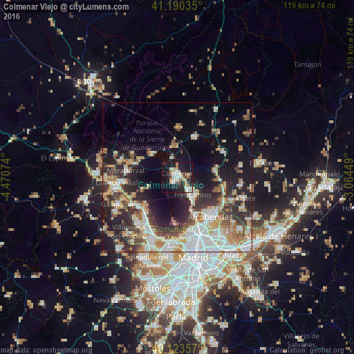

Analysis of Colmenar Viejo night lights 2016
Square area 10x10 km:
 8.12%
8.12%90-99
9.42%80-89
2.27%70-79
4.06%60-69
3.9%50-59
1.95%40-49
4.55%30-39
2.76%20-29
13.31%10-19
36.36%0-9
13.31%Square area 50x50 km:
7.02%90-99
7.09%80-89
2.83%70-79
4.01%60-69
4.32%50-59
3.57%40-49
3.97%30-39
4.77%20-29
9.08%10-19
13.17%0-9
40.18%Clear (daylight) street map image can be seen on geolist.org.
Map coordinates:
41° 11' 25.3" North, 4° 28' 14.7" West
40° 39' 32.7" North, 3° 46' 3.4" West
40° 7' 24.9" North, 3° 3' 52.2" West
Some cities around Colmenar Viejo sort by population:
• Alcobendas
16.3 km =10.1 mi,  139°
139°
• Tres Cantos
8.2 km =5.1 mi, 142°
• Torrelodones
16.3 km =10.1 mi,  235°
235°
• Las Matas
15.4 km =9.6 mi,  222°
222°
• San Agustín del Guadalix
12.9 km =8 mi,  80°
80°
• Hoyo de Manzanares
12.5 km =7.8 mi,  251°
251°
• Manzanares el Real
11 km =6.8 mi,  312°
312°
• Boalo
14.1 km =8.8 mi,  296°
296°
3124765 (p: 43,700)
Sources (retrieved 2019-11-25):
» Earth at Night: Flat Maps 2012, 2016