Alameda night lights from space
Night Light of Alameda (Andalusia) from space (Spain) Src. Average luminocity for 10x10km area is 6.5034% and for 50x50km: 7.1266%.
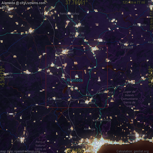
Analysis of Alameda night lights 2016
Square area 10x10 km:
 0.68%
0.68%90-99
0.68%80-89
2.04%70-79
0%60-69
0.17%50-59
0.51%40-49
1.87%30-39
0.85%20-29
0.68%10-19
0%0-9
92.52%Square area 50x50 km:
0.51%90-99
0.81%80-89
1.31%70-79
0.92%60-69
1.29%50-59
0.6%40-49
0.78%30-39
0.97%20-29
0.67%10-19
3.15%0-9
88.99%Clear (daylight) street map image can be seen on geolist.org.
Map coordinates:
37° 45' 59.8" North, 5° 21' 42.2" West
37° 12' 31.3" North, 4° 39' 31" West
36° 38' 47.9" North, 3° 57' 19.7" West
Some cities around Alameda sort by population:
• Antequera
22.8 km =14.2 mi,  157°
157°
• Lucena
27 km =16.8 mi,  34°
34°
• Puente-Genil
22.3 km =13.9 mi,  334°
334°
• Estepa
21.6 km =13.4 mi,  295°
295°
• Campillos
25.4 km =15.8 mi,  225°
225°
• Herrera
24.2 km =15 mi,  315°
315°
• Casariche
13 km =8.1 mi, 316°
• Pedrera
21 km =13 mi,  275°
275°
2522291 (p: 5,241)
Sources (retrieved 2019-11-25):
» Earth at Night: Flat Maps 2012, 2016