Estepa night lights from space
Night Light of Estepa (Andalusia) from space (Spain) Src. Average luminocity for 10x10km area is 15.4594% and for 50x50km: 5.5935%.
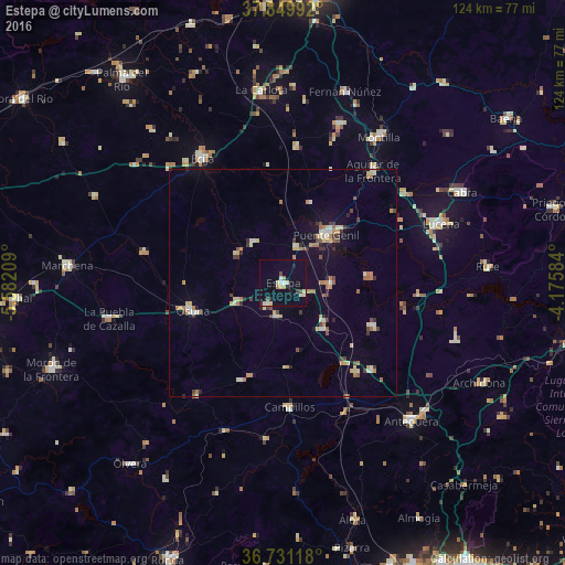
Analysis of Estepa night lights 2016
Square area 10x10 km:
 1.62%
1.62%90-99
1.79%80-89
4.38%70-79
0.97%60-69
0.97%50-59
0.16%40-49
1.79%30-39
0.65%20-29
1.62%10-19
6.66%0-9
79.38%Square area 50x50 km:
0.41%90-99
0.62%80-89
1.06%70-79
0.5%60-69
1.14%50-59
0.42%40-49
0.57%30-39
0.84%20-29
0.54%10-19
1.69%0-9
92.21%Clear (daylight) street map image can be seen on geolist.org.
Map coordinates:
37° 50' 59.7" North, 5° 34' 55.5" West
37° 17' 33.5" North, 4° 52' 44.3" West
36° 43' 52.2" North, 4° 10' 33" West
Some cities around Estepa sort by population:
• Puente-Genil
14.6 km =9.1 mi,  42°
42°
• Osuna
20.8 km =12.9 mi,  252°
252°
• Campillos
27.2 km =16.9 mi,  177°
177°
• Herrera
8.3 km =5.2 mi,  18°
18°
• Santaella
30.2 km =18.8 mi,  5°
5°
• Casariche
10.5 km =6.5 mi,  89°
89°
• Alameda
21.6 km =13.4 mi,  115°
115°
• Pedrera
7.5 km =4.7 mi,  190°
190°
2517820 (p: 12,632)
Sources (retrieved 2019-11-25):
» Earth at Night: Flat Maps 2012, 2016