Paján night lights from space
Night Light of Paján (Manabí) from space (Ecuador) Src. Average luminocity for 10x10km area is 11.3874% and for 50x50km: 1.3107%.
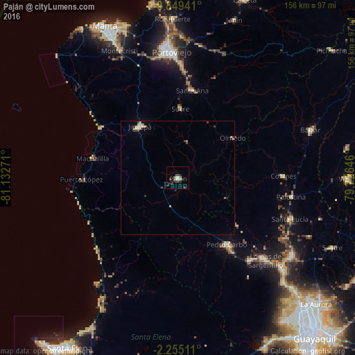
Analysis of Paján night lights 2016
Square area 10x10 km:
 1.52%
1.52%90-99
1.95%80-89
0.87%70-79
0%60-69
0.22%50-59
2.81%40-49
3.03%30-39
3.46%20-29
4.33%10-19
0.87%0-9
80.95%Square area 50x50 km:
0.15%90-99
0.17%80-89
0.17%70-79
0.16%60-69
0.11%50-59
0.15%40-49
0.25%30-39
0.37%20-29
0.28%10-19
0.1%0-9
98.09%Clear (daylight) street map image can be seen on geolist.org.
Map coordinates:
0° 50' 57.9" South, 81° 7' 57.8" West
1° 33' 8.6" South, 80° 25' 46.5" West
2° 15' 18.4" South, 79° 43' 35.3" West
Some cities around Paján sort by population:
• Portoviejo
55.4 km =34.4 mi,  357°
357°
• Jipijapa
28.1 km =17.5 mi,  323°
323°
• Pedro Carbo
36.5 km =22.7 mi,  143°
143°
• Montecristi
61.8 km =38.4 mi,  335°
335°
• Sucre
30.3 km =18.8 mi,  2°
2°
• Santa Ana
38.9 km =24.2 mi,  9°
9°
• Colimes
46.5 km =28.9 mi,  89°
89°
• Lomas de Sargentillo
53.2 km =33.1 mi,  133°
133°
3653609 (p: 9,183)
Sources (retrieved 2019-11-25):
» Earth at Night: Flat Maps 2012, 2016