Montecristi night lights from space
Night Light of Montecristi (Manabí) from space (Ecuador) Src. Average luminocity for 10x10km area is 31.5887% and for 50x50km: 13.1334%.
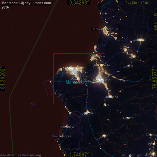
Analysis of Montecristi night lights 2016
Square area 10x10 km:
 2.38%
2.38%90-99
2.16%80-89
4.98%70-79
4.11%60-69
8.01%50-59
1.95%40-49
5.41%30-39
8.44%20-29
13.85%10-19
27.06%0-9
21.65%Square area 50x50 km:
1.44%90-99
1.71%80-89
1.93%70-79
2.09%60-69
2.27%50-59
0.8%40-49
2.1%30-39
2.67%20-29
3.26%10-19
10.27%0-9
71.46%Clear (daylight) street map image can be seen on geolist.org.
Map coordinates:
0° 20' 33.7" South, 81° 21' 43.3" West
1° 2' 44.7" South, 80° 39' 32" West
1° 44' 55.2" South, 79° 57' 20.8" West
Some cities around Montecristi sort by population:
• Manta
11.1 km =6.9 mi,  327°
327°
• Portoviejo
22.7 km =14.1 mi,  92°
92°
• Jipijapa
34.8 km =21.6 mi,  165°
165°
• Sucre
37.3 km =23.2 mi,  134°
134°
• Tosagua
55.3 km =34.4 mi,  58°
58°
• Santa Ana
36.7 km =22.8 mi,  119°
119°
• Rocafuerte
27 km =16.8 mi, 59°
• Junín
52 km =32.3 mi,  75°
75°
3654055 (p: 18,351)
Sources (retrieved 2019-11-25):
» Earth at Night: Flat Maps 2012, 2016