Lomas de Sargentillo night lights from space
Night Light of Lomas de Sargentillo (Guayas) from space (Ecuador) Src. Average luminocity for 10x10km area is 31.4697% and for 50x50km: 17.2607%.
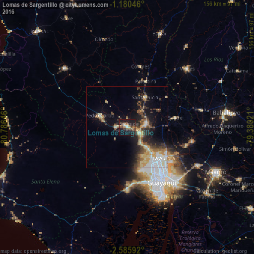
Analysis of Lomas de Sargentillo night lights 2016
Square area 10x10 km:
 1.95%
1.95%90-99
2.6%80-89
3.46%70-79
4.98%60-69
3.9%50-59
3.03%40-49
9.52%30-39
7.14%20-29
8.66%10-19
48.92%0-9
5.84%Square area 50x50 km:
2.63%90-99
2.17%80-89
3.2%70-79
2.37%60-69
2.02%50-59
1.83%40-49
2.98%30-39
3.11%20-29
3.75%10-19
9.62%0-9
66.31%Clear (daylight) street map image can be seen on geolist.org.
Map coordinates:
1° 10' 49.7" South, 80° 47' 11.3" West
1° 52' 60" South, 80° 4' 60" West
2° 35' 9.3" South, 79° 22' 48.8" West
Some cities around Lomas de Sargentillo sort by population:
• Guayaquil
41.1 km =25.5 mi,  147°
147°
• Eloy Alfaro
41.2 km =25.6 mi,  142°
142°
• El Triunfo
14.1 km =8.8 mi,  113°
113°
• Samborondón
40.9 km =25.4 mi,  102°
102°
• Pedro Carbo
18.3 km =11.4 mi,  294°
294°
• Santa Lucía
34.6 km =21.5 mi,  164°
164°
• Colimes
38.4 km =23.9 mi,  11°
11°
• Palestina
41.5 km =25.8 mi, 98°
3654650 (p: 7,542)
Sources (retrieved 2019-11-25):
» Earth at Night: Flat Maps 2012, 2016