Montalvo night lights from space
Night Light of Montalvo (Los Ríos) from space (Ecuador) Src. Average luminocity for 10x10km area is 2.3009% and for 50x50km: 1.5816%.
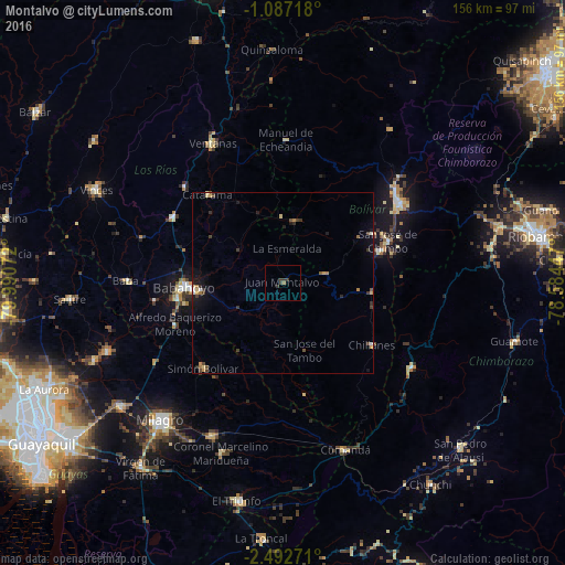
Analysis of Montalvo night lights 2016
Square area 10x10 km:
 0%
0%90-99
0%80-89
0%70-79
0%60-69
0.87%50-59
0%40-49
0.22%30-39
4.11%20-29
0%10-19
0%0-9
94.81%Square area 50x50 km:
0.08%90-99
0.1%80-89
0.2%70-79
0.21%60-69
0.28%50-59
0.11%40-49
0.38%30-39
0.52%20-29
0.25%10-19
0.94%0-9
96.94%Clear (daylight) street map image can be seen on geolist.org.
Map coordinates:
1° 5' 13.8" South, 79° 59' 26.6" West
1° 47' 24.3" South, 79° 17' 15.3" West
2° 29' 33.8" South, 78° 35' 4.1" West
Some cities around Montalvo sort by population:
• Babahoyo
27.5 km =17.1 mi,  267°
267°
• Ventanas
43.2 km =26.8 mi,  333°
333°
• Naranjito
46.3 km =28.8 mi,  205°
205°
• Guaranda
38.7 km =24 mi,  55°
55°
• Alfredo Baquerizo Moreno
29.1 km =18.1 mi,  241°
241°
• San Miguel
28.6 km =17.8 mi,  71°
71°
• Catarama
30.6 km =19 mi,  321°
321°
• Coronel Marcelino Maridueña
49.3 km =30.6 mi,  199°
199°
3654064 (p: 15,547)
Sources (retrieved 2019-11-25):
» Earth at Night: Flat Maps 2012, 2016