Alfredo Baquerizo Moreno night lights from space
Night Light of Alfredo Baquerizo Moreno (Guayas) from space (Ecuador) Src. Average luminocity for 10x10km area is 3.2294% and for 50x50km: 5.4116%.
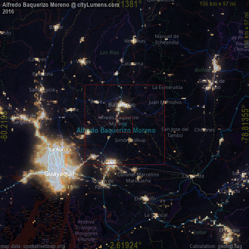
Analysis of Alfredo Baquerizo Moreno night lights 2016
Square area 10x10 km:
 0.43%
0.43%90-99
0.43%80-89
0%70-79
0%60-69
0.87%50-59
0%40-49
0.87%30-39
0.87%20-29
0.87%10-19
0%0-9
95.67%Square area 50x50 km:
0.63%90-99
0.65%80-89
0.41%70-79
0.53%60-69
0.76%50-59
0.56%40-49
1.15%30-39
1.12%20-29
0.92%10-19
5.4%0-9
87.88%Clear (daylight) street map image can be seen on geolist.org.
Map coordinates:
1° 12' 49.7" South, 80° 13' 11.3" West
1° 55' 0" South, 79° 31' 0" West
2° 37' 9.3" South, 78° 48' 48.8" West
Some cities around Alfredo Baquerizo Moreno sort by population:
• Milagro
25.7 km =16 mi,  199°
199°
• Babahoyo
12.9 km =8 mi,  351°
351°
• Naranjito
28.4 km =17.6 mi,  168°
168°
• Yaguachi Nuevo
28.2 km =17.5 mi,  224°
224°
• Samborondón
23.6 km =14.7 mi,  257°
257°
• Montalvo
29.1 km =18.1 mi,  61°
61°
• Palestina
22 km =13.7 mi, 264°
• Coronel Marcelino Maridueña
33.8 km =21 mi,  163°
163°
3660773 (p: 12,617)
Sources (retrieved 2019-11-25):
» Earth at Night: Flat Maps 2012, 2016