Tamalous night lights from space
Night Light of Tamalous (Skikda) from space (Algeria) Src. Average luminocity for 10x10km area is 17.9968% and for 50x50km: 10.3205%.

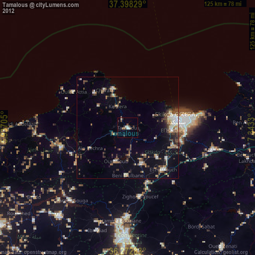
Analysis of Tamalous night lights 2016
Square area 10x10 km:
 1.46%
1.46%90-99
1.14%80-89
1.95%70-79
3.57%60-69
3.25%50-59
0.32%40-49
1.95%30-39
4.87%20-29
3.57%10-19
19.64%0-9
58.28%Square area 50x50 km:
0.81%90-99
1.33%80-89
1.18%70-79
1.35%60-69
1.17%50-59
1.07%40-49
1.65%30-39
2.03%20-29
2.29%10-19
9.1%0-9
78.02%Clear (daylight) street map image can be seen on geolist.org.
Map coordinates:
37° 23' 53.8" North, 5° 56' 13.4" East
36° 50' 15.5" North, 6° 38' 24.6" East
36° 16' 22.2" North, 7° 20' 35.9" East
Some cities around Tamalous sort by population:
• Constantine
52.6 km =32.7 mi,  182°
182°
• Skikda
24.3 km =15.1 mi,  79°
79°
• Azzaba
42.8 km =26.6 mi,  104°
104°
• Mila
54.6 km =33.9 mi,  217°
217°
• Hamma Bouziane
47.5 km =29.5 mi, 184°
• Karkira
11.3 km =7 mi,  334°
334°
• Didouche Mourad
42.8 km =26.6 mi, 180°
• Sidi Mérouane
48.8 km =30.3 mi, 223°
2478226 (p: 32,579)
Sources (retrieved 2019-11-25):
» Earth at Night: Flat Maps 2012, 2016