Oued el Alleug night lights from space
Night Light of Oued el Alleug (Tipaza) from space (Algeria) Src. Average luminocity for 10x10km area is 52.2674% and for 50x50km: 35.6644%.

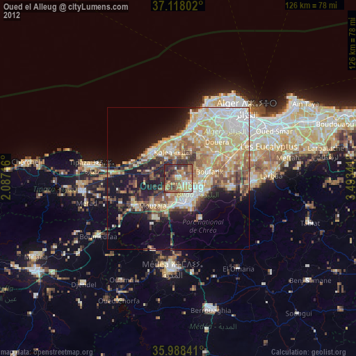
Analysis of Oued el Alleug night lights 2016
Square area 10x10 km:
 4.03%
4.03%90-99
6.96%80-89
5.68%70-79
4.95%60-69
15.2%50-59
12.45%40-49
11.54%30-39
18.32%20-29
19.78%10-19
1.1%0-9
0%Square area 50x50 km:
6.46%90-99
6.86%80-89
4.9%70-79
5.64%60-69
7.47%50-59
3.88%40-49
3.86%30-39
4.83%20-29
6.32%10-19
13.15%0-9
36.64%Clear (daylight) street map image can be seen on geolist.org.
Map coordinates:
37° 7' 4.9" North, 2° 5' 13.8" East
36° 33' 19" North, 2° 47' 25" East
35° 59' 18.3" North, 3° 29' 36.3" East
Some cities around Oued el Alleug sort by population:
• Blida
10.1 km =6.3 mi,  160°
160°
• Beni Mered
7.2 km =4.5 mi,  118°
118°
• Boufarik
11.1 km =6.9 mi,  79°
79°
• Boû Arfa
10.5 km =6.5 mi,  168°
168°
• Souma
11.1 km =6.9 mi,  111°
111°
• Kolea
9.5 km =5.9 mi,  348°
348°
• Chiffa
11.3 km =7 mi,  204°
204°
• Bou Ismaïl
13.2 km =8.2 mi,  317°
317°
2485633 (p: 21,146)
Sources (retrieved 2019-11-25):
» Earth at Night: Flat Maps 2012, 2016