Chabet el Ameur night lights from space
Night Light of Chabet el Ameur (Boumerdes) from space (Algeria) Src. Average luminocity for 10x10km area is 16.0678% and for 50x50km: 23.0534%.
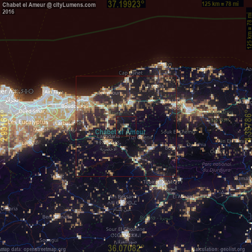
Analysis of Chabet el Ameur night lights 2016
Square area 10x10 km:
 0%
0%90-99
0.73%80-89
0.73%70-79
0%60-69
2.2%50-59
2.56%40-49
2.56%30-39
10.81%20-29
3.11%10-19
27.47%0-9
49.82%Square area 50x50 km:
0.91%90-99
2.44%80-89
2.14%70-79
3.08%60-69
4.32%50-59
2.98%40-49
3.98%30-39
7.16%20-29
9.52%10-19
22.21%0-9
41.25%Clear (daylight) street map image can be seen on geolist.org.
Map coordinates:
37° 11' 57.2" North, 2° 59' 29.8" East
36° 38' 13.5" North, 3° 41' 41.1" East
36° 4' 15" North, 4° 23' 52.3" East
Some cities around Chabet el Ameur sort by population:
• Boumerdas
24.1 km =15 mi,  306°
306°
• Lakhdaria
12.1 km =7.5 mi,  228°
228°
• Draa el Mizan
16.7 km =10.4 mi,  132°
132°
• Tizi Gheniff
8.9 km =5.5 mi, 127°
• Tadmaït
21.9 km =13.6 mi,  57°
57°
• Beni Amrane
9.8 km =6.1 mi,  290°
290°
• Thenia
15.8 km =9.8 mi, 308°
• Naciria
17.2 km =10.7 mi,  45°
45°
2501873 (p: 19,522)
Sources (retrieved 2019-11-25):
» Earth at Night: Flat Maps 2012, 2016