Naciria night lights from space
Night Light of Naciria (Boumerdes) from space (Algeria) Src. Average luminocity for 10x10km area is 22.6171% and for 50x50km: 21.0899%.
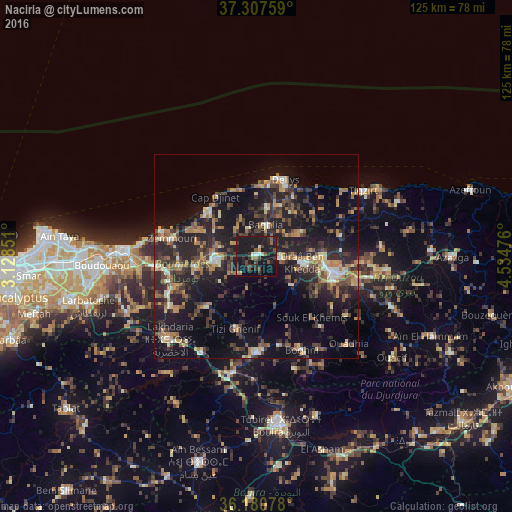
Analysis of Naciria night lights 2016
Square area 10x10 km:
 1.05%
1.05%90-99
1.57%80-89
0.87%70-79
1.57%60-69
2.45%50-59
2.8%40-49
5.24%30-39
7.17%20-29
8.57%10-19
53.15%0-9
15.56%Square area 50x50 km:
0.86%90-99
2.37%80-89
1.93%70-79
2.73%60-69
3.7%50-59
2.96%40-49
3.62%30-39
5.98%20-29
8.55%10-19
21.61%0-9
45.7%Clear (daylight) street map image can be seen on geolist.org.
Map coordinates:
37° 18' 27.3" North, 3° 7' 42.6" East
36° 44' 46.5" North, 3° 49' 53.9" East
36° 10' 50.8" North, 4° 32' 5.1" East
Some cities around Naciria sort by population:
• Tizi Ouzou
19.5 km =12.1 mi,  101°
101°
• Draa Ben Khedda
11.7 km =7.3 mi, 96°
• Makouda
21 km =13 mi,  77°
77°
• Tizi Gheniff
18.3 km =11.4 mi,  196°
196°
• Dellys
20.3 km =12.6 mi,  20°
20°
• Tirmitine
16.8 km =10.4 mi,  127°
127°
• Tadmaït
6.1 km =3.8 mi,  92°
92°
• Chabet el Ameur
17.2 km =10.7 mi,  225°
225°
2486505 (p: 15,387)
Sources (retrieved 2019-11-25):
» Earth at Night: Flat Maps 2012, 2016