Beni Amrane night lights from space
Night Light of Beni Amrane (Boumerdes) from space (Algeria) Src. Average luminocity for 10x10km area is 40.7601% and for 50x50km: 25.8933%.
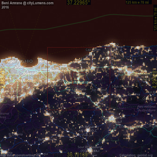
Analysis of Beni Amrane night lights 2016
Square area 10x10 km:
 0.55%
0.55%90-99
5.86%80-89
2.93%70-79
7.51%60-69
7.69%50-59
6.04%40-49
7.69%30-39
13.37%20-29
33.7%10-19
14.65%0-9
0%Square area 50x50 km:
2.12%90-99
3.66%80-89
2.55%70-79
4.16%60-69
4.94%50-59
2.66%40-49
3.64%30-39
6.63%20-29
9.32%10-19
19.77%0-9
40.54%Clear (daylight) street map image can be seen on geolist.org.
Map coordinates:
37° 13' 46.7" North, 2° 53' 16.9" East
36° 40' 3.9" North, 3° 35' 28.1" East
36° 6' 6.1" North, 4° 17' 39.4" East
Some cities around Beni Amrane sort by population:
• Boumerdas
15 km =9.3 mi,  317°
317°
• Lakhdaria
11.5 km =7.1 mi,  179°
179°
• Boudouaou
17.5 km =10.9 mi,  292°
292°
• Tizi Gheniff
18.6 km =11.6 mi,  118°
118°
• Chabet el Ameur
9.8 km =6.1 mi,  110°
110°
• Arbatache
19.9 km =12.4 mi,  260°
260°
• Thenia
7.1 km =4.4 mi,  334°
334°
• Ouled Moussa
20.1 km =12.5 mi,  275°
275°
2504739 (p: 18,414)
Sources (retrieved 2019-11-25):
» Earth at Night: Flat Maps 2012, 2016