Bougaa night lights from space
Night Light of Bougaa (Sétif) from space (Algeria) Src. Average luminocity for 10x10km area is 20.7203% and for 50x50km: 9.9985%.
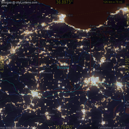

Analysis of Bougaa night lights 2016
Square area 10x10 km:
 0.52%
0.52%90-99
4.55%80-89
1.92%70-79
6.64%60-69
0.35%50-59
1.22%40-49
1.75%30-39
3.5%20-29
2.62%10-19
19.06%0-9
57.87%Square area 50x50 km:
0.39%90-99
1.33%80-89
0.92%70-79
1.84%60-69
1.07%50-59
0.83%40-49
1.73%30-39
2.77%20-29
2.38%10-19
5.27%0-9
81.47%Clear (daylight) street map image can be seen on geolist.org.
Map coordinates:
36° 53' 50.3" North, 4° 23' 7.1" East
36° 19' 58.5" North, 5° 5' 18.3" East
35° 45' 52" North, 5° 47' 29.6" East
Some cities around Bougaa sort by population:
• Sétif
33.2 km =20.6 mi,  118°
118°
• Bordj Bou Arreridj
41.2 km =25.6 mi,  225°
225°
• Aïn Arnat
25.9 km =16.1 mi,  128°
128°
• Barbacha
28.2 km =17.5 mi,  337°
337°
• Amizour
38 km =23.6 mi,  333°
333°
• Feraoun
32.8 km =20.4 mi,  320°
320°
• Seddouk
43.2 km =26.8 mi,  303°
303°
• Bordj Zemoura
21.8 km =13.5 mi,  252°
252°
2503156 (p: 38,597)
Sources (retrieved 2019-11-25):
» Earth at Night: Flat Maps 2012, 2016