Bordj Zemoura night lights from space
Night Light of Bordj Zemoura (Bordj Bou Arréridj) from space (Algeria) Src. Average luminocity for 10x10km area is 12.8619% and for 50x50km: 11.7954%.
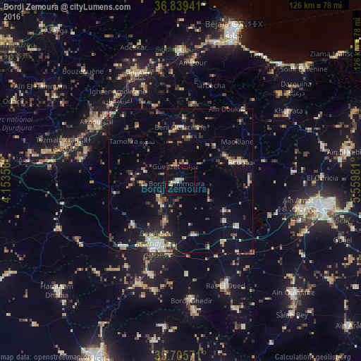
Analysis of Bordj Zemoura night lights 2016
Square area 10x10 km:
 0%
0%90-99
4.02%80-89
0.17%70-79
3.15%60-69
0.7%50-59
0%40-49
0.87%30-39
2.62%20-29
0.7%10-19
8.39%0-9
79.37%Square area 50x50 km:
0.62%90-99
1.91%80-89
0.96%70-79
2.35%60-69
1.11%50-59
0.9%40-49
1.67%30-39
2.79%20-29
2.72%10-19
7.09%0-9
77.89%Clear (daylight) street map image can be seen on geolist.org.
Map coordinates:
36° 50' 21.9" North, 4° 9' 12.8" East
36° 16' 28.6" North, 4° 51' 24" East
35° 42' 20.6" North, 5° 33' 35.3" East
Some cities around Bordj Zemoura sort by population:
• El Achir
31.2 km =19.4 mi,  221°
221°
• Akbou
35.3 km =21.9 mi,  305°
305°
• Râs el Oued
39.9 km =24.8 mi,  156°
156°
• Bougaa
21.8 km =13.5 mi,  72°
72°
• Barbacha
33.9 km =21.1 mi,  16°
16°
• Feraoun
31.8 km =19.8 mi,  359°
359°
• Seddouk
33.9 km =21.1 mi,  333°
333°
• Ighram
37.8 km =23.5 mi,  303°
303°
2503620 (p: 19,782)
Sources (retrieved 2019-11-25):
» Earth at Night: Flat Maps 2012, 2016