Ighram night lights from space
Night Light of Ighram (Tizi Ouzou) from space (Algeria) Src. Average luminocity for 10x10km area is 34.4469% and for 50x50km: 13.2562%.
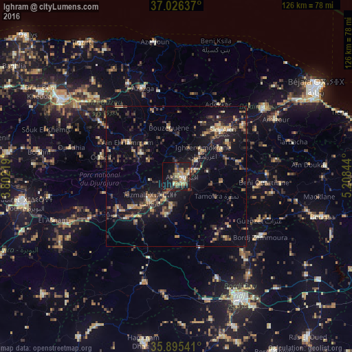
Analysis of Ighram night lights 2016
Square area 10x10 km:
 0.92%
0.92%90-99
3.11%80-89
6.23%70-79
9.52%60-69
5.49%50-59
3.3%40-49
8.42%30-39
5.31%20-29
6.78%10-19
33.33%0-9
17.58%Square area 50x50 km:
0.11%90-99
1.13%80-89
1.47%70-79
2.32%60-69
2.04%50-59
1.49%40-49
2.45%30-39
3.75%20-29
3.17%10-19
13.9%0-9
68.17%Clear (daylight) street map image can be seen on geolist.org.
Map coordinates:
37° 1' 34.9" North, 3° 48' 7.9" East
36° 27' 46.6" North, 4° 30' 19.2" East
35° 53' 43.5" North, 5° 12' 30.4" East
Some cities around Ighram sort by population:
• Akbou
2.7 km =1.7 mi,  102°
102°
• el hed
31.7 km =19.7 mi,  49°
49°
• Mekla
32.5 km =20.2 mi,  318°
318°
• ’Aïn el Hammam
21.1 km =13.1 mi,  302°
302°
• Feraoun
33 km =20.5 mi,  70°
70°
• Chemini
18.2 km =11.3 mi,  33°
33°
• Chorfa
19.4 km =12.1 mi,  235°
235°
• Seddouk
18.7 km =11.6 mi,  59°
59°
2493605 (p: 15,030)
Sources (retrieved 2019-11-25):
» Earth at Night: Flat Maps 2012, 2016