’Aïn Boucif night lights from space
Night Light of ’Aïn Boucif (Medea) from space (Algeria) Src. Average luminocity for 10x10km area is 6.4451% and for 50x50km: 1.4774%.
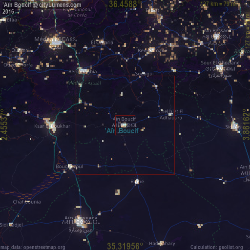
Analysis of ’Aïn Boucif night lights 2016
Square area 10x10 km:
 1.47%
1.47%90-99
0.73%80-89
0%70-79
0.55%60-69
1.65%50-59
0.73%40-49
0%30-39
1.47%20-29
2.2%10-19
1.47%0-9
89.74%Square area 50x50 km:
0.1%90-99
0.26%80-89
0.27%70-79
0.12%60-69
0.18%50-59
0.15%40-49
0.33%30-39
0.24%20-29
0.29%10-19
0.27%0-9
97.8%Clear (daylight) street map image can be seen on geolist.org.
Map coordinates:
36° 27' 31.7" North, 2° 27' 19.3" East
35° 53' 28.4" North, 3° 9' 30.6" East
35° 19' 10.4" North, 3° 51' 41.8" East
Some cities around ’Aïn Boucif sort by population:
• Médéa
55.1 km =34.2 mi,  318°
318°
• Aïn Oussera
54 km =33.6 mi,  205°
205°
• Berrouaghia
35.1 km =21.8 mi, 320°
• Ksar el Boukhari
36.9 km =22.9 mi,  269°
269°
• Sidi Aïssa
55.3 km =34.4 mi,  90°
90°
• Birine
29.1 km =18.1 mi,  168°
168°
• Sour el Ghozlane
55.8 km =34.7 mi,  59°
59°
• ‘Aïn el Hadjel
69.7 km =43.3 mi,  110°
110°
2508262 (p: 11,989)
Sources (retrieved 2019-11-25):
» Earth at Night: Flat Maps 2012, 2016