Tenares night lights from space
Night Light of Tenares (Hermanas Mirabal) from space (Dominican Republic) Src. Average luminocity for 10x10km area is 14.186% and for 50x50km: 10.801%.
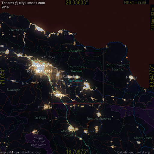
Analysis of Tenares night lights 2016
Square area 10x10 km:
 0.62%
0.62%90-99
0.21%80-89
0.83%70-79
1.65%60-69
2.69%50-59
1.03%40-49
5.79%30-39
3.31%20-29
3.93%10-19
7.44%0-9
72.52%Square area 50x50 km:
0.71%90-99
1.17%80-89
1.1%70-79
0.92%60-69
1.42%50-59
1.37%40-49
2.12%30-39
3.68%20-29
3.7%10-19
10.49%0-9
73.32%Clear (daylight) street map image can be seen on geolist.org.
Map coordinates:
20° 2' 10.8" North, 71° 3' 14.4" West
19° 22' 27.8" North, 70° 21' 3.1" West
18° 42' 35.1" North, 69° 38' 51.9" West
Some cities around Tenares sort by population:
• San Francisco de Macorís
13.2 km =8.2 mi,  128°
128°
• Concepción de La Vega
25.3 km =15.7 mi,  227°
227°
• Moca
18.5 km =11.5 mi,  276°
276°
• Salcedo
7 km =4.3 mi,  272°
272°
• Salsipuedes
4.6 km =2.9 mi,  318°
318°
• Las Guáranas
25.1 km =15.6 mi,  143°
143°
• Veragua Arriba
23.3 km =14.5 mi,  4°
4°
• San Víctor Arriba
22.5 km =14 mi,  300°
300°
3492477 (p: 7,390)
Sources (retrieved 2019-11-25):
» Earth at Night: Flat Maps 2012, 2016