Las Guáranas night lights from space
Night Light of Las Guáranas (Duarte) from space (Dominican Republic) Src. Average luminocity for 10x10km area is 6.881% and for 50x50km: 6.3862%.
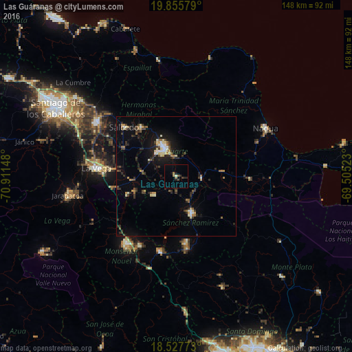
Analysis of Las Guáranas night lights 2016
Square area 10x10 km:
 0%
0%90-99
0.43%80-89
0.43%70-79
0%60-69
2.6%50-59
0.87%40-49
1.73%30-39
0.87%20-29
1.95%10-19
2.38%0-9
88.74%Square area 50x50 km:
0.42%90-99
0.84%80-89
0.69%70-79
0.56%60-69
0.76%50-59
0.71%40-49
0.96%30-39
1.35%20-29
1.94%10-19
4.13%0-9
87.64%Clear (daylight) street map image can be seen on geolist.org.
Map coordinates:
19° 51' 20.8" North, 70° 54' 41.3" West
19° 11' 35.2" North, 70° 12' 30.1" West
18° 31' 39.8" North, 69° 30' 18.8" West
Some cities around Las Guáranas sort by population:
• San Francisco de Macorís
12.9 km =8 mi,  338°
338°
• Cotuí
16.8 km =10.4 mi,  158°
158°
• Fantino
12.5 km =7.8 mi,  230°
230°
• Pimentel
10.5 km =6.5 mi,  95°
95°
• Tenares
25.1 km =15.6 mi,  323°
323°
• Castillo
19.1 km =11.9 mi,  84°
84°
• Jima Abajo
18.8 km =11.7 mi,  249°
249°
• Rincón
22.4 km =13.9 mi, 248°
3500518 (p: 9,586)
Sources (retrieved 2019-11-25):
» Earth at Night: Flat Maps 2012, 2016