Fantino night lights from space
Night Light of Fantino (Sánchez Ramírez) from space (Dominican Republic) Src. Average luminocity for 10x10km area is 7.5758% and for 50x50km: 10.2106%.
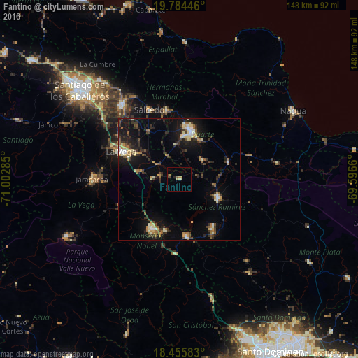
Analysis of Fantino night lights 2016
Square area 10x10 km:
 0%
0%90-99
0.65%80-89
1.95%70-79
2.6%60-69
0%50-59
0.87%40-49
1.3%30-39
1.3%20-29
0.87%10-19
0%0-9
90.48%Square area 50x50 km:
0.73%90-99
1.41%80-89
1.33%70-79
0.88%60-69
1.43%50-59
1.23%40-49
1.24%30-39
2.53%20-29
2.8%10-19
8.02%0-9
78.41%Clear (daylight) street map image can be seen on geolist.org.
Map coordinates:
19° 47' 4.1" North, 71° 0' 10.3" West
19° 7' 17.3" North, 70° 17' 59" West
18° 27' 21" North, 69° 35' 47.8" West
Some cities around Fantino sort by population:
• San Francisco de Macorís
20.6 km =12.8 mi,  13°
13°
• Concepción de La Vega
26.6 km =16.5 mi,  294°
294°
• Bonao
23.5 km =14.6 mi,  209°
209°
• Cotuí
17.5 km =10.9 mi,  115°
115°
• Las Guáranas
12.5 km =7.8 mi,  50°
50°
• Pimentel
21.2 km =13.2 mi,  70°
70°
• Jima Abajo
8.1 km =5 mi,  279°
279°
• Rincón
11.2 km =7 mi,  268°
268°
3505778 (p: 10,024)
Sources (retrieved 2019-11-25):
» Earth at Night: Flat Maps 2012, 2016