Neder Holluf night lights from space
Night Light of Neder Holluf (South Denmark) from space (Denmark) Src. Average luminocity for 10x10km area is 42.2727% and for 50x50km: 5.5127%.
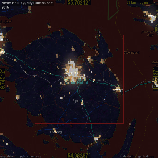
Analysis of Neder Holluf night lights 2016
Square area 10x10 km:
 9.21%
9.21%90-99
11%80-89
5.74%70-79
4.67%60-69
3.59%50-59
5.62%40-49
1.44%30-39
3.11%20-29
12.92%10-19
20.81%0-9
21.89%Square area 50x50 km:
0.88%90-99
0.97%80-89
0.63%70-79
0.54%60-69
0.6%50-59
0.76%40-49
0.71%30-39
1.06%20-29
1.44%10-19
2.84%0-9
89.57%Clear (daylight) street map image can be seen on geolist.org.
Map coordinates:
55° 45' 43.6" North, 9° 44' 42.4" East
55° 21' 52.2" North, 10° 26' 53.7" East
54° 57' 46.3" North, 11° 9' 4.9" East
Some cities around Neder Holluf sort by population:
• Odense
5.2 km =3.2 mi,  312°
312°
• Svendborg
35.3 km =21.9 mi,  163°
163°
• Nyborg
22.3 km =13.9 mi,  104°
104°
• Korsør
43.8 km =27.2 mi, 95°
• Faaborg
32.7 km =20.3 mi,  203°
203°
• Assens
36.2 km =22.5 mi,  253°
253°
• Kerteminde
16.2 km =10.1 mi,  54°
54°
• Munkebo
12.1 km =7.5 mi,  33°
33°
2616540 (p: 5,612)
Sources (retrieved 2019-11-25):
» Earth at Night: Flat Maps 2012, 2016