Kongens Lyngby night lights from space
Night Light of Kongens Lyngby (Capital Region) from space (Denmark) Src. Average luminocity for 10x10km area is 70.1758% and for 50x50km: 23.5663%.
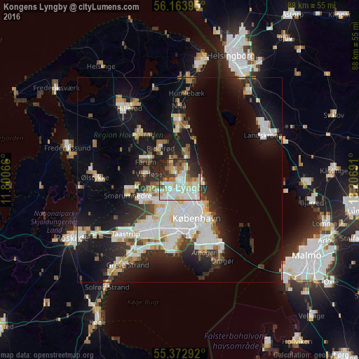
Analysis of Kongens Lyngby night lights 2016
Square area 10x10 km:
 20.22%
90-99
20.81%80-89
11.84%70-79
4.07%60-69
6.7%50-59
6.22%40-49
5.62%30-39
8.61%20-29
12.32%10-19
3.59%0-9
0%Square area 50x50 km:
6.03%90-99
5.48%80-89
2.25%70-79
1.89%60-69
2.01%50-59
2.09%40-49
2.08%30-39
2.42%20-29
5.61%10-19
15.46%0-9
54.69%Clear (daylight) street map image can be seen on geolist.org.
Map coordinates:
56° 9' 50.2" North, 11° 48' 2.4" East
55° 46' 13.6" North, 12° 30' 13.6" East
55° 22' 22.5" North, 13° 12' 24.9" East
Some cities around Kongens Lyngby sort by population:
• Ballerup
9.8 km =6.1 mi,  243°
243°
• Charlottenlund
4.9 km =3 mi,  114°
114°
• Vanløse
9.7 km =6 mi,  186°
186°
• Birkerød
9.8 km =6.1 mi,  331°
331°
• Farum
9.9 km =6.2 mi,  295°
295°
• Værløse
8.6 km =5.3 mi,  279°
279°
• Trørød
8.1 km =5 mi,  18°
18°
• Stavnsholt
7.9 km =4.9 mi,  308°
308°
2618468 (p: 10,600)
Sources (retrieved 2019-11-25):
» Earth at Night: Flat Maps 2012, 2016