Trørød night lights from space
Night Light of Trørød (Capital Region) from space (Denmark) Src. Average luminocity for 10x10km area is 23.3481% and for 50x50km: 23.6934%.
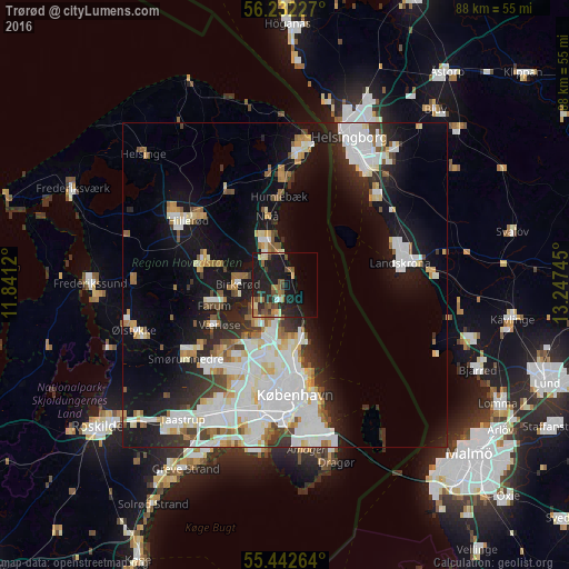
Analysis of Trørød night lights 2016
Square area 10x10 km:
 0.96%
0.96%90-99
1.32%80-89
3.11%70-79
1.67%60-69
5.14%50-59
4.07%40-49
5.14%30-39
3.35%20-29
10.41%10-19
31.46%0-9
33.37%Square area 50x50 km:
6.71%90-99
5.99%80-89
2.17%70-79
1.8%60-69
2.03%50-59
1.97%40-49
1.78%30-39
2.17%20-29
4.36%10-19
13.61%0-9
57.41%Clear (daylight) street map image can be seen on geolist.org.
Map coordinates:
56° 13' 56.2" North, 11° 50' 28.3" East
55° 50' 22.1" North, 12° 32' 39.6" East
55° 26' 33.5" North, 13° 14' 50.8" East
Some cities around Trørød sort by population:
• Charlottenlund
9.9 km =6.2 mi,  168°
168°
• Hørsholm
5.3 km =3.3 mi,  329°
329°
• Birkerød
7.3 km =4.5 mi,  277°
277°
• Farum
12 km =7.5 mi,  253°
253°
• Værløse
12.7 km =7.9 mi,  240°
240°
• Kongens Lyngby
8.1 km =5 mi,  198°
198°
• Nivå
10.8 km =6.7 mi,  346°
346°
• Stavnsholt
9.1 km =5.7 mi, 252°
2611189 (p: 8,576)
Sources (retrieved 2019-11-25):
» Earth at Night: Flat Maps 2012, 2016