Farum night lights from space
Night Light of Farum (Capital Region) from space (Denmark) Src. Average luminocity for 10x10km area is 25.1699% and for 50x50km: 23.8135%.
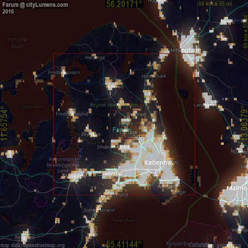
Analysis of Farum night lights 2016
Square area 10x10 km:
 1.32%
1.32%90-99
3.47%80-89
0.84%70-79
1.2%60-69
3.71%50-59
3.83%40-49
5.86%30-39
4.19%20-29
16.39%10-19
37.56%0-9
21.65%Square area 50x50 km:
6.14%90-99
5.73%80-89
2.29%70-79
2%60-69
2.14%50-59
2.21%40-49
2.11%30-39
2.54%20-29
5.18%10-19
13.07%0-9
56.57%Clear (daylight) street map image can be seen on geolist.org.
Map coordinates:
56° 12' 6.2" North, 11° 39' 27.1" East
55° 48' 30.9" North, 12° 21' 38.4" East
55° 24' 41.2" North, 13° 3' 49.6" East
Some cities around Farum sort by population:
• Ballerup
8.6 km =5.3 mi,  178°
178°
• Birkerød
6 km =3.7 mi,  44°
44°
• Lillerød
7.4 km =4.6 mi,  352°
352°
• Værløse
2.9 km =1.8 mi,  170°
170°
• Kongens Lyngby
9.9 km =6.2 mi,  115°
115°
• Smørumnedre
8.2 km =5.1 mi,  206°
206°
• Måløv
6.4 km =4 mi,  201°
201°
• Stavnsholt
2.9 km =1.8 mi,  76°
76°
2622306 (p: 18,376)
Sources (retrieved 2019-11-25):
» Earth at Night: Flat Maps 2012, 2016