Wilsdruff night lights from space
Night Light of Wilsdruff (Saxony) from space (Germany) Src. Average luminocity for 10x10km area is 10.6297% and for 50x50km: 10.0934%.
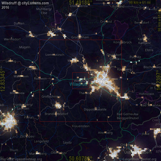
Analysis of Wilsdruff night lights 2016
Square area 10x10 km:
 1.2%
1.2%90-99
1.47%80-89
0.67%70-79
1.47%60-69
1.07%50-59
0.94%40-49
0.94%30-39
1.34%20-29
0.8%10-19
14.04%0-9
76.07%Square area 50x50 km:
1.73%90-99
1.87%80-89
0.73%70-79
1.23%60-69
1.24%50-59
1.48%40-49
1.27%30-39
1.51%20-29
2.3%10-19
6.16%0-9
80.49%Clear (daylight) street map image can be seen on geolist.org.
Map coordinates:
51° 29' 30.8" North, 12° 50' 0.4" East
51° 3' 7.2" North, 13° 32' 11.7" East
50° 36' 28.4" North, 14° 14' 22.9" East
Some cities around Wilsdruff sort by population:
• Dresden
14.1 km =8.8 mi,  90°
90°
• Freital
9.6 km =6 mi,  125°
125°
• Radebeul
10.6 km =6.6 mi,  54°
54°
• Meissen
13 km =8.1 mi,  340°
340°
• Coswig
9.5 km =5.9 mi,  20°
20°
• Weinböhla
12.9 km =8 mi,  9°
9°
• Klipphausen
2.4 km =1.5 mi,  318°
318°
• Tharandt
8 km =5 mi,  157°
157°
2808436 (p: 13,772)
Sources (retrieved 2019-11-25):
» Earth at Night: Flat Maps 2012, 2016