Weißenhorn night lights from space
Night Light of Weißenhorn (Bavaria) from space (Germany) Src. Average luminocity for 10x10km area is 7.0412% and for 50x50km: 6.7377%.
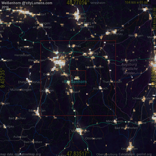
Analysis of Weißenhorn night lights 2016
Square area 10x10 km:
 0.14%
0.14%90-99
1.28%80-89
0.28%70-79
1.14%60-69
1.7%50-59
0%40-49
1.14%30-39
0.14%20-29
1.42%10-19
1.56%0-9
91.19%Square area 50x50 km:
0.86%90-99
1.03%80-89
0.47%70-79
0.84%60-69
0.74%50-59
0.67%40-49
1.37%30-39
1.14%20-29
1.49%10-19
4.05%0-9
87.34%Clear (daylight) street map image can be seen on geolist.org.
Map coordinates:
48° 46' 14" North, 9° 27' 26.5" East
48° 18' 18" North, 10° 9' 37.7" East
47° 50' 6.6" North, 10° 51' 49" East
Some cities around Weißenhorn sort by population:
• Neu-Ulm
14.7 km =9.1 mi,  311°
311°
• Senden
8.8 km =5.5 mi,  284°
284°
• Illertissen
10 km =6.2 mi,  204°
204°
• Vöhringen
6.5 km =4 mi,  242°
242°
• Nersingen
14 km =8.7 mi,  348°
348°
• Ichenhausen
13.1 km =8.1 mi,  55°
55°
• Pfaffenhofen an der Roth
5.5 km =3.4 mi,  1°
1°
• Dietenheim
12.4 km =7.7 mi,  212°
212°
2811879 (p: 13,377)
Sources (retrieved 2019-11-25):
» Earth at Night: Flat Maps 2012, 2016