Nersingen night lights from space
Night Light of Nersingen (Bavaria) from space (Germany) Src. Average luminocity for 10x10km area is 6.7827% and for 50x50km: 8.0042%.
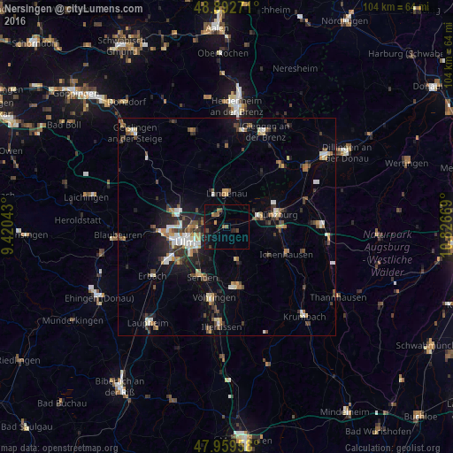
Analysis of Nersingen night lights 2016
Square area 10x10 km:
 0%
0%90-99
0%80-89
0%70-79
0.85%60-69
0.71%50-59
2.41%40-49
1.85%30-39
0.71%20-29
1.14%10-19
8.24%0-9
84.09%Square area 50x50 km:
0.93%90-99
1.2%80-89
0.63%70-79
0.96%60-69
0.86%50-59
1%40-49
1.49%30-39
1.43%20-29
1.68%10-19
4.78%0-9
85.04%Clear (daylight) street map image can be seen on geolist.org.
Map coordinates:
48° 53' 33.8" North, 9° 25' 13.5" East
48° 25' 41.8" North, 10° 7' 24.8" East
47° 57' 34.5" North, 10° 49' 36.1" East
Some cities around Nersingen sort by population:
• Ulm
10.3 km =6.4 mi,  251°
251°
• Neu-Ulm
9.2 km =5.7 mi,  244°
244°
• Senden
12.9 km =8 mi,  206°
206°
• Günzburg
11.7 km =7.3 mi,  74°
74°
• Langenau
7.6 km =4.7 mi,  357°
357°
• Dornstadt
13.9 km =8.6 mi,  288°
288°
• Pfaffenhofen an der Roth
8.7 km =5.4 mi,  160°
160°
• Leipheim
7.7 km =4.8 mi, 71°
2866473 (p: 9,177)
Sources (retrieved 2019-11-25):
» Earth at Night: Flat Maps 2012, 2016