Ichenhausen night lights from space
Night Light of Ichenhausen (Bavaria) from space (Germany) Src. Average luminocity for 10x10km area is 3.5653% and for 50x50km: 5.8773%.
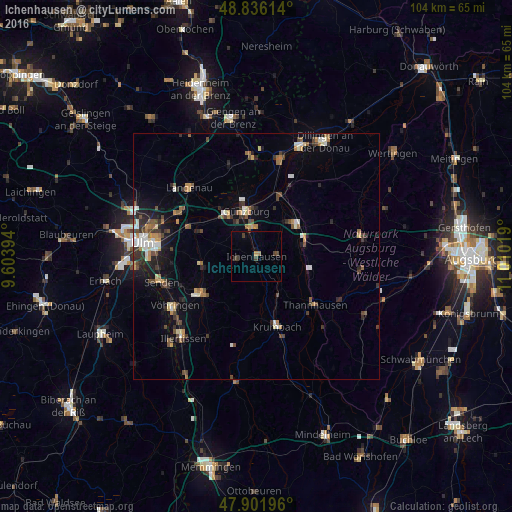
Analysis of Ichenhausen night lights 2016
Square area 10x10 km:
 0%
0%90-99
0%80-89
0%70-79
0.57%60-69
0.57%50-59
0%40-49
2.41%30-39
1.28%20-29
0%10-19
0.57%0-9
94.6%Square area 50x50 km:
0.61%90-99
0.83%80-89
0.47%70-79
0.71%60-69
0.75%50-59
0.71%40-49
1.27%30-39
1.12%20-29
1.19%10-19
2.82%0-9
89.52%Clear (daylight) street map image can be seen on geolist.org.
Map coordinates:
48° 50' 10.1" North, 9° 36' 14.2" East
48° 22' 16.3" North, 10° 18' 25.4" East
47° 54' 7.1" North, 11° 0' 36.7" East
Some cities around Ichenhausen sort by population:
• Günzburg
9.7 km =6 mi,  346°
346°
• Weißenhorn
13.1 km =8.1 mi,  235°
235°
• Krumbach
15 km =9.3 mi,  163°
163°
• Burgau
10.1 km =6.3 mi,  48°
48°
• Nersingen
15 km =9.3 mi,  295°
295°
• Pfaffenhofen an der Roth
10.9 km =6.8 mi,  260°
260°
• Jettingen-Scheppach
9.9 km =6.2 mi,  78°
78°
• Leipheim
10.7 km =6.6 mi,  324°
324°
2896776 (p: 8,499)
Sources (retrieved 2019-11-25):
» Earth at Night: Flat Maps 2012, 2016