Weißenburg in Bayern night lights from space
Night Light of Weißenburg in Bayern (Bavaria) from space (Germany) Src. Average luminocity for 10x10km area is 6.5208% and for 50x50km: 1.4005%.
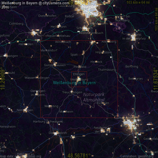
Analysis of Weißenburg in Bayern night lights 2016
Square area 10x10 km:
 0.45%
0.45%90-99
0.3%80-89
1.64%70-79
1.19%60-69
1.19%50-59
0.74%40-49
2.23%30-39
0%20-29
0%10-19
0.6%0-9
91.67%Square area 50x50 km:
0.05%90-99
0.15%80-89
0.22%70-79
0.13%60-69
0.38%50-59
0.19%40-49
0.34%30-39
0.27%20-29
0.33%10-19
0.19%0-9
97.75%Clear (daylight) street map image can be seen on geolist.org.
Map coordinates:
49° 29' 23.4" North, 10° 16' 8.7" East
49° 1' 51.4" North, 10° 58' 20" East
48° 34' 4.1" North, 11° 40' 31.2" East
Some cities around Weißenburg in Bayern sort by population:
• Gunzenhausen
18.2 km =11.3 mi,  301°
301°
• Treuchtlingen
9.7 km =6 mi,  208°
208°
• Eichstätt
22.8 km =14.2 mi,  134°
134°
• Pleinfeld
8.2 km =5.1 mi,  4°
4°
• Georgensgmünd
17.9 km =11.1 mi,  10°
10°
• Thalmässing
19.3 km =12 mi,  70°
70°
• Spalt
16.4 km =10.2 mi,  347°
347°
• Heideck
16.1 km =10 mi,  44°
44°
2811909 (p: 17,801)
Sources (retrieved 2019-11-25):
» Earth at Night: Flat Maps 2012, 2016