Heideck night lights from space
Night Light of Heideck (Bavaria) from space (Germany) Src. Average luminocity for 10x10km area is 0.7619% and for 50x50km: 2.935%.
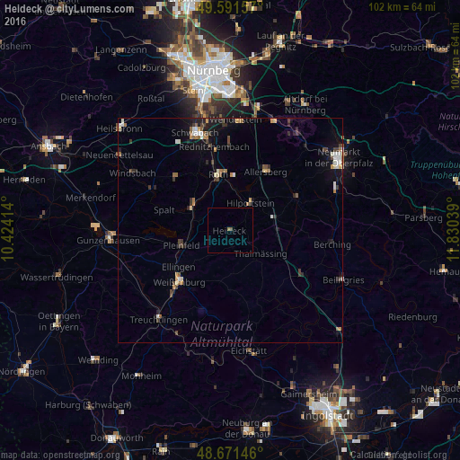
Analysis of Heideck night lights 2016
Square area 10x10 km:
 0%
0%90-99
0%80-89
0%70-79
0%60-69
0.56%50-59
0%40-49
0.56%30-39
0%20-29
0%10-19
0%0-9
98.88%Square area 50x50 km:
0.29%90-99
0.43%80-89
0.23%70-79
0.32%60-69
0.42%50-59
0.36%40-49
0.53%30-39
0.56%20-29
0.58%10-19
1.88%0-9
94.41%Clear (daylight) street map image can be seen on geolist.org.
Map coordinates:
49° 35' 29.7" North, 10° 25' 26.9" East
49° 8' 1.1" North, 11° 7' 38.1" East
48° 40' 17.3" North, 11° 49' 49.4" East
Some cities around Heideck sort by population:
• Roth
12.9 km =8 mi,  348°
348°
• Hilpoltstein
7.8 km =4.8 mi,  36°
36°
• Allersberg
15.3 km =9.5 mi,  31°
31°
• Pleinfeld
11.1 km =6.9 mi,  253°
253°
• Georgensgmünd
10.2 km =6.3 mi,  307°
307°
• Thalmässing
8.5 km =5.3 mi,  126°
126°
• Büchenbach
15.7 km =9.8 mi,  341°
341°
• Spalt
15.5 km =9.6 mi,  287°
287°
2907983 (p: 5,011)
Sources (retrieved 2019-11-25):
» Earth at Night: Flat Maps 2012, 2016