Gunzenhausen night lights from space
Night Light of Gunzenhausen (Bavaria) from space (Germany) Src. Average luminocity for 10x10km area is 5.605% and for 50x50km: 2.6825%.
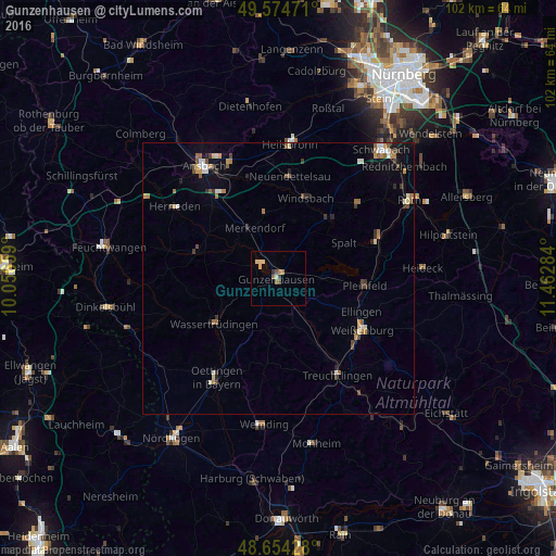
Analysis of Gunzenhausen night lights 2016
Square area 10x10 km:
 0%
0%90-99
0.56%80-89
1.82%70-79
0.42%60-69
1.68%50-59
1.4%40-49
0.28%30-39
0.84%20-29
0.28%10-19
0%0-9
92.72%Square area 50x50 km:
0.27%90-99
0.33%80-89
0.32%70-79
0.26%60-69
0.47%50-59
0.46%40-49
0.44%30-39
0.42%20-29
0.33%10-19
1.07%0-9
95.63%Clear (daylight) street map image can be seen on geolist.org.
Map coordinates:
49° 34' 29" North, 10° 3' 23.7" East
49° 6' 59.9" North, 10° 45' 35" East
48° 39' 15.4" North, 11° 27' 46.2" East
Some cities around Gunzenhausen sort by population:
• Weißenburg in Bayern
18.2 km =11.3 mi,  121°
121°
• Neuendettelsau
18.6 km =11.6 mi,  5°
5°
• Pleinfeld
16.2 km =10.1 mi,  94°
94°
• Georgensgmünd
20.4 km =12.7 mi,  66°
66°
• Wassertrüdingen
14.3 km =8.9 mi,  235°
235°
• Windsbach
15.4 km =9.6 mi,  18°
18°
• Abenberg
20.4 km =12.7 mi,  46°
46°
• Spalt
13.7 km =8.5 mi,  61°
61°
2913537 (p: 16,477)
Sources (retrieved 2019-11-25):
» Earth at Night: Flat Maps 2012, 2016