Weinheim night lights from space
Night Light of Weinheim (Baden-Württemberg) from space (Germany) Src. Average luminocity for 10x10km area is 21.9482% and for 50x50km: 20.4139%.
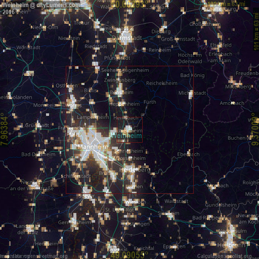
Analysis of Weinheim night lights 2016
Square area 10x10 km:
 2.38%
2.38%90-99
3.22%80-89
2.24%70-79
2.24%60-69
2.8%50-59
2.38%40-49
2.94%30-39
2.1%20-29
9.66%10-19
32.21%0-9
37.82%Square area 50x50 km:
4.12%90-99
4.66%80-89
1.73%70-79
1.69%60-69
1.87%50-59
2.27%40-49
2.09%30-39
2.88%20-29
7.68%10-19
14.19%0-9
56.83%Clear (daylight) street map image can be seen on geolist.org.
Map coordinates:
50° 0' 10.5" North, 7° 57' 49.8" East
49° 32' 55.9" North, 8° 40' 1.1" East
49° 5' 26" North, 9° 22' 12.3" East
Some cities around Weinheim sort by population:
• Viernheim
6.5 km =4 mi,  261°
261°
• Schriesheim
8.4 km =5.2 mi,  181°
181°
• Hemsbach
4.9 km =3 mi,  343°
343°
• Heddesheim
6.6 km =4.1 mi,  223°
223°
• Mörlenbach
7.4 km =4.6 mi,  41°
41°
• Birkenau
3.3 km =2.1 mi,  62°
62°
• Hirschberg an der Bergstraße
4.7 km =2.9 mi,  188°
188°
• Laudenbach
7.2 km =4.5 mi,  352°
352°
2812174 (p: 43,325)
Sources (retrieved 2019-11-25):
» Earth at Night: Flat Maps 2012, 2016