Birkenau night lights from space
Night Light of Birkenau (Hesse) from space (Germany) Src. Average luminocity for 10x10km area is 14.0392% and for 50x50km: 18.1074%.
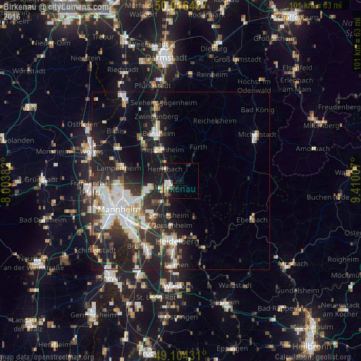
Analysis of Birkenau night lights 2016
Square area 10x10 km:
 2.1%
2.1%90-99
3.5%80-89
0.56%70-79
1.68%60-69
2.1%50-59
0.7%40-49
1.26%30-39
1.96%20-29
3.08%10-19
15.13%0-9
67.93%Square area 50x50 km:
3.7%90-99
4.08%80-89
1.59%70-79
1.48%60-69
1.63%50-59
2.1%40-49
1.78%30-39
2.61%20-29
6.6%10-19
12.24%0-9
62.19%Clear (daylight) street map image can be seen on geolist.org.
Map coordinates:
50° 0' 59.1" North, 8° 0' 13.8" East
49° 33' 45" North, 8° 42' 25" East
49° 6' 15.5" North, 9° 24' 36.3" East
Some cities around Birkenau sort by population:
• Weinheim
3.3 km =2.1 mi,  242°
242°
• Viernheim
9.6 km =6 mi,  255°
255°
• Hemsbach
5.3 km =3.3 mi,  306°
306°
• Wald-Michelbach
9 km =5.6 mi,  84°
84°
• Mörlenbach
4.5 km =2.8 mi,  26°
26°
• Hirschberg an der Bergstraße
7.1 km =4.4 mi,  210°
210°
• Rimbach
8 km =5 mi, 30°
• Laudenbach
6.8 km =4.2 mi,  325°
325°
2948652 (p: 10,318)
Sources (retrieved 2019-11-25):
» Earth at Night: Flat Maps 2012, 2016