Heddesheim night lights from space
Night Light of Heddesheim (Baden-Württemberg) from space (Germany) Src. Average luminocity for 10x10km area is 48.0182% and for 50x50km: 22.5901%.
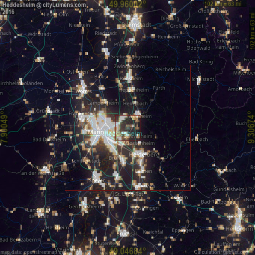
Analysis of Heddesheim night lights 2016
Square area 10x10 km:
 6.16%
6.16%90-99
10.36%80-89
5.18%70-79
5.04%60-69
7%50-59
7.14%40-49
7.7%30-39
10.64%20-29
22.83%10-19
17.65%0-9
0.28%Square area 50x50 km:
4.43%90-99
4.98%80-89
1.82%70-79
1.78%60-69
2.19%50-59
2.33%40-49
2.51%30-39
3.24%20-29
8.86%10-19
17.5%0-9
50.35%Clear (daylight) street map image can be seen on geolist.org.
Map coordinates:
49° 57' 36.1" North, 7° 54' 1.8" East
49° 30' 20" North, 8° 36' 13" East
49° 2' 48.6" North, 9° 18' 24.3" East
Some cities around Heddesheim sort by population:
• Weinheim
6.6 km =4.1 mi,  43°
43°
• Viernheim
4.3 km =2.7 mi,  334°
334°
• Schriesheim
5.6 km =3.5 mi,  129°
129°
• Edingen-Neckarhausen
5.4 km =3.4 mi,  177°
177°
• Dossenheim
8 km =5 mi,  140°
140°
• Ladenburg
3.6 km =2.2 mi,  173°
173°
• Hirschberg an der Bergstraße
3.9 km =2.4 mi,  87°
87°
• Ilvesheim
4.4 km =2.7 mi,  216°
216°
2908398 (p: 11,544)
Sources (retrieved 2019-11-25):
» Earth at Night: Flat Maps 2012, 2016