Mörlenbach night lights from space
Night Light of Mörlenbach (Hesse) from space (Germany) Src. Average luminocity for 10x10km area is 2.4202% and for 50x50km: 15.7418%.
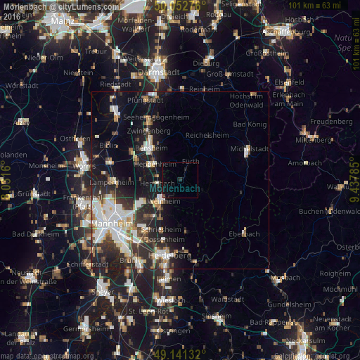
Analysis of Mörlenbach night lights 2016
Square area 10x10 km:
 0.14%
0.14%90-99
0.14%80-89
0%70-79
0%60-69
0%50-59
0%40-49
0.56%30-39
0%20-29
1.54%10-19
3.5%0-9
94.12%Square area 50x50 km:
3.34%90-99
3.61%80-89
1.38%70-79
1.29%60-69
1.32%50-59
1.65%40-49
1.6%30-39
2.25%20-29
5.15%10-19
10.44%0-9
67.97%Clear (daylight) street map image can be seen on geolist.org.
Map coordinates:
50° 3' 9.9" North, 8° 1' 53.8" East
49° 35' 57" North, 8° 44' 5" East
49° 8' 28.8" North, 9° 26' 16.3" East
Some cities around Mörlenbach sort by population:
• Weinheim
7.4 km =4.6 mi,  221°
221°
• Heppenheim an der Bergstrasse
8.8 km =5.5 mi,  302°
302°
• Hemsbach
6.3 km =3.9 mi,  261°
261°
• Wald-Michelbach
7.7 km =4.8 mi,  114°
114°
• Fürth
6.8 km =4.2 mi,  32°
32°
• Birkenau
4.5 km =2.8 mi,  206°
206°
• Rimbach
3.5 km =2.2 mi,  35°
35°
• Laudenbach
6 km =3.7 mi,  285°
285°
2869221 (p: 10,568)
Sources (retrieved 2019-11-25):
» Earth at Night: Flat Maps 2012, 2016