Weida night lights from space
Night Light of Weida (Thuringia) from space (Germany) Src. Average luminocity for 10x10km area is 1.8796% and for 50x50km: 3.866%.
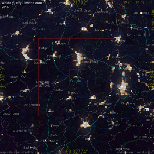
Analysis of Weida night lights 2016
Square area 10x10 km:
 0%
0%90-99
0%80-89
0.56%70-79
0.56%60-69
0%50-59
0%40-49
0.56%30-39
0%20-29
0%10-19
0.56%0-9
97.76%Square area 50x50 km:
0.43%90-99
0.52%80-89
0.43%70-79
0.58%60-69
0.45%50-59
0.64%40-49
0.41%30-39
0.53%20-29
0.39%10-19
1.98%0-9
93.63%Clear (daylight) street map image can be seen on geolist.org.
Map coordinates:
51° 13' 1.3" North, 11° 21' 25.8" East
50° 46' 28.2" North, 12° 3' 37" East
50° 19' 39.9" North, 12° 45' 48.3" East
Some cities around Weida sort by population:
• Gera
11.9 km =7.4 mi,  7°
7°
• Greiz
16.2 km =10.1 mi,  143°
143°
• Zeulenroda
14.6 km =9.1 mi,  201°
201°
• Hermsdorf
19.8 km =12.3 mi,  313°
313°
• Neustadt an der Orla
22.5 km =14 mi,  259°
259°
• Fraureuth
22 km =13.7 mi,  112°
112°
• Ronneburg
13.3 km =8.3 mi,  41°
41°
• Elsterberg
20 km =12.4 mi,  157°
157°
2813110 (p: 8,528)
Sources (retrieved 2019-11-25):
» Earth at Night: Flat Maps 2012, 2016