Wald-Michelbach night lights from space
Night Light of Wald-Michelbach (Hesse) from space (Germany) Src. Average luminocity for 10x10km area is 0.0462% and for 50x50km: 11.1353%.
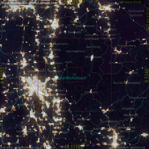
Analysis of Wald-Michelbach night lights 2016
Square area 10x10 km:
 0%
0%90-99
0%80-89
0%70-79
0%60-69
0%50-59
0%40-49
0%30-39
0%20-29
0%10-19
0%0-9
100%Square area 50x50 km:
1.78%90-99
2.35%80-89
1.14%70-79
0.91%60-69
1.1%50-59
1.41%40-49
1.16%30-39
1.62%20-29
4.66%10-19
7.83%0-9
76.04%Clear (daylight) street map image can be seen on geolist.org.
Map coordinates:
50° 1' 25.9" North, 8° 7' 42.8" East
49° 34' 12" North, 8° 49' 54" East
49° 6' 42.8" North, 9° 32' 5.3" East
Some cities around Wald-Michelbach sort by population:
• Weinheim
12.1 km =7.5 mi,  258°
258°
• Hemsbach
13.5 km =8.4 mi,  279°
279°
• Fürth
9.6 km =6 mi,  339°
339°
• Mörlenbach
7.7 km =4.8 mi,  294°
294°
• Birkenau
9 km =5.6 mi, 264°
• Rimbach
7.9 km =4.9 mi,  321°
321°
• Beerfelden
10.3 km =6.4 mi,  90°
90°
• Lindenfels
13.1 km =8.1 mi, 344°
2814853 (p: 11,720)
Sources (retrieved 2019-11-25):
» Earth at Night: Flat Maps 2012, 2016