Fürth night lights from space
Night Light of Fürth (Hesse) from space (Germany) Src. Average luminocity for 10x10km area is 0.1457% and for 50x50km: 12.6538%.
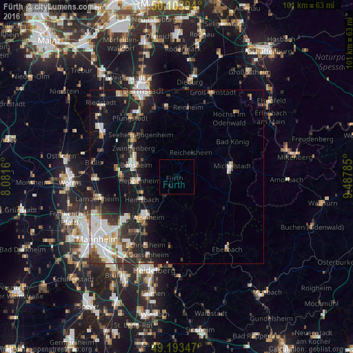
Analysis of Fürth night lights 2016
Square area 10x10 km:
 0%
0%90-99
0%80-89
0%70-79
0%60-69
0%50-59
0%40-49
0%30-39
0%20-29
0.56%10-19
0%0-9
99.44%Square area 50x50 km:
2.49%90-99
2.78%80-89
1.11%70-79
1.13%60-69
1.1%50-59
1.32%40-49
1.43%30-39
1.74%20-29
3.75%10-19
9.12%0-9
74.04%Clear (daylight) street map image can be seen on geolist.org.
Map coordinates:
50° 6' 14.2" North, 8° 4' 53.8" East
49° 39' 3" North, 8° 47' 5" East
49° 11' 36.5" North, 9° 29' 16.3" East
Some cities around Fürth sort by population:
• Heppenheim an der Bergstrasse
11 km =6.8 mi,  264°
264°
• Wald-Michelbach
9.6 km =6 mi,  159°
159°
• Mörlenbach
6.8 km =4.2 mi,  212°
212°
• Reichelsheim
7.9 km =4.9 mi,  29°
29°
• Rimbach
3.3 km =2.1 mi, 208°
• Lützelbach
10.3 km =6.4 mi,  352°
352°
• Laudenbach
10.3 km =6.4 mi,  246°
246°
• Lindenfels
3.7 km =2.3 mi,  356°
356°
2923543 (p: 11,181)
Sources (retrieved 2019-11-25):
» Earth at Night: Flat Maps 2012, 2016