Beerfelden night lights from space
Night Light of Beerfelden (Hesse) from space (Germany) Src. Average luminocity for 10x10km area is 0.1919% and for 50x50km: 4.5149%.
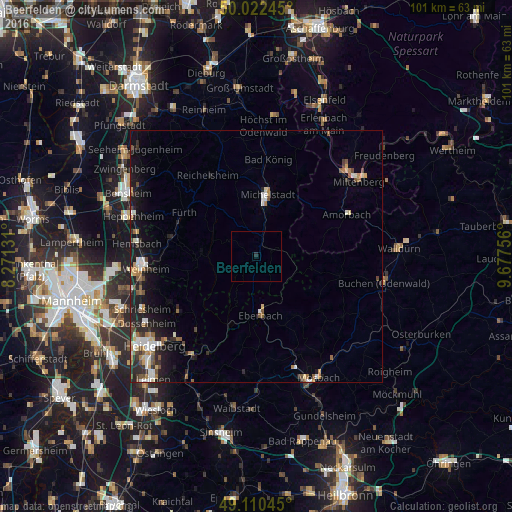
Analysis of Beerfelden night lights 2016
Square area 10x10 km:
 0%
0%90-99
0%80-89
0%70-79
0%60-69
0%50-59
0%40-49
0%30-39
0%20-29
0.56%10-19
0%0-9
99.44%Square area 50x50 km:
0.55%90-99
0.78%80-89
0.42%70-79
0.42%60-69
0.53%50-59
0.78%40-49
0.55%30-39
0.5%20-29
1.53%10-19
3.56%0-9
90.38%Clear (daylight) street map image can be seen on geolist.org.
Map coordinates:
50° 1' 20.8" North, 8° 16' 16.7" East
49° 34' 6.9" North, 8° 58' 28" East
49° 6' 37.6" North, 9° 40' 39.2" East
Some cities around Beerfelden sort by population:
• Michelstadt
12.1 km =7.5 mi,  10°
10°
• Eberbach
11.4 km =7.1 mi,  174°
174°
• Erbach
10.4 km =6.5 mi, 7°
• Wald-Michelbach
10.3 km =6.4 mi,  270°
270°
• Fürth
16.4 km =10.2 mi,  303°
303°
• Mörlenbach
17.6 km =10.9 mi,  281°
281°
• Rimbach
16.5 km =10.3 mi,  292°
292°
• Mudau
17 km =10.6 mi,  102°
102°
2951556 (p: 6,942)
Sources (retrieved 2019-11-25):
» Earth at Night: Flat Maps 2012, 2016