Wagenfeld night lights from space
Night Light of Wagenfeld (Lower Saxony) from space (Germany) Src. Average luminocity for 10x10km area is 0% and for 50x50km: 0.7623%.
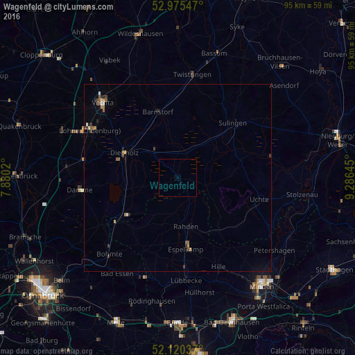
Analysis of Wagenfeld night lights 2016
Square area 10x10 km:
 0%
0%90-99
0%80-89
0%70-79
0%60-69
0%50-59
0%40-49
0%30-39
0%20-29
0%10-19
0%0-9
100%Square area 50x50 km:
0.04%90-99
0.09%80-89
0.05%70-79
0.09%60-69
0.14%50-59
0.17%40-49
0.14%30-39
0.16%20-29
0.16%10-19
0.07%0-9
98.89%Clear (daylight) street map image can be seen on geolist.org.
Map coordinates:
52° 58' 31.7" North, 7° 52' 48.7" East
52° 33' 0" North, 8° 34' 60" East
52° 7' 13.3" North, 9° 17' 11.2" East
Some cities around Wagenfeld sort by population:
• Espelkamp
18.8 km =11.7 mi,  172°
172°
• Diepholz
15.8 km =9.8 mi,  294°
294°
• Hille
26.6 km =16.5 mi,  154°
154°
• Rahden
13.1 km =8.1 mi, 171°
• Damme
26.3 km =16.3 mi,  263°
263°
• Sulingen
21.3 km =13.2 mi,  45°
45°
• Steinfeld
25.3 km =15.7 mi,  279°
279°
• Barnstorf
18.6 km =11.6 mi,  342°
342°
2815523 (p: 7,132)
Sources (retrieved 2019-11-25):
» Earth at Night: Flat Maps 2012, 2016