Espelkamp night lights from space
Night Light of Espelkamp (North Rhine-Westphalia) from space (Germany) Src. Average luminocity for 10x10km area is 1.9293% and for 50x50km: 2.4055%.
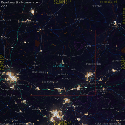

Analysis of Espelkamp night lights 2016
Square area 10x10 km:
 0%
0%90-99
0%80-89
0%70-79
1.01%60-69
0.25%50-59
0.25%40-49
1.01%30-39
0.38%20-29
0.38%10-19
0%0-9
96.72%Square area 50x50 km:
0.17%90-99
0.37%80-89
0.19%70-79
0.21%60-69
0.33%50-59
0.46%40-49
0.56%30-39
0.4%20-29
0.31%10-19
0.83%0-9
96.17%Clear (daylight) street map image can be seen on geolist.org.
Map coordinates:
52° 48' 34.6" North, 7° 55' 5.3" East
52° 22' 57" North, 8° 37' 16.6" East
51° 57' 4.5" North, 9° 19' 27.8" East
Some cities around Espelkamp sort by population:
• Lübbecke
8.4 km =5.2 mi,  183°
183°
• Hille
10.3 km =6.4 mi,  122°
122°
• Kirchlengern
20.3 km =12.6 mi, 177°
• Rahden
5.7 km =3.5 mi,  354°
354°
• Hüllhorst
11.5 km =7.1 mi,  164°
164°
• Preußisch Oldendorf
12.2 km =7.6 mi,  225°
225°
• Rödinghausen
17.5 km =10.9 mi,  212°
212°
• Wagenfeld
18.8 km =11.7 mi, 352°
2928874 (p: 26,378)
Sources (retrieved 2019-11-25):
» Earth at Night: Flat Maps 2012, 2016