Voerde night lights from space
Night Light of Voerde (North Rhine-Westphalia) from space (Germany) Src. Average luminocity for 10x10km area is 25.238% and for 50x50km: 25.3147%.
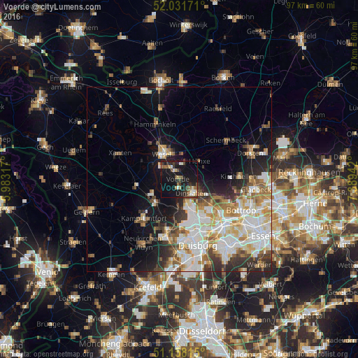
Analysis of Voerde night lights 2016
Square area 10x10 km:
 2.81%
2.81%90-99
2.41%80-89
3.21%70-79
1.2%60-69
2.14%50-59
5.75%40-49
3.21%30-39
5.48%20-29
7.35%10-19
38.9%0-9
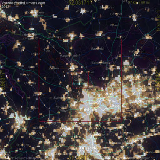
27.54%Square area 50x50 km:
6.24%90-99
5.77%80-89
2.82%70-79
2.9%60-69
2.95%50-59
2.89%40-49
2.57%30-39
2.97%20-29
4.34%10-19
9.09%0-9
57.47%Clear (daylight) street map image can be seen on geolist.org.
Map coordinates:
52° 1' 54.2" North, 5° 58' 59.4" East
51° 35' 49.3" North, 6° 41' 10.7" East
51° 9' 29.3" North, 7° 23' 21.9" East
Some cities around Voerde sort by population:
• Dinslaken
5.5 km =3.4 mi,  134°
134°
• Wesel
9 km =5.6 mi,  329°
329°
• Meiderich
15.5 km =9.6 mi,  159°
159°
• Kamp-Lintfort
14.1 km =8.8 mi,  223°
223°
• Rheinberg
8.4 km =5.2 mi,  228°
228°
• Hünxe
4.2 km =2.6 mi,  10°
10°
• Schermbeck
15.7 km =9.8 mi,  52°
52°
• Alpen
11.8 km =7.3 mi,  262°
262°
2817065 (p: 38,759)
Sources (retrieved 2019-11-25):
» Earth at Night: Flat Maps 2012, 2016