Hünxe night lights from space
Night Light of Hünxe (North Rhine-Westphalia) from space (Germany) Src. Average luminocity for 10x10km area is 20.0448% and for 50x50km: 23.9483%.
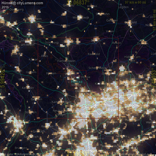
Analysis of Hünxe night lights 2016
Square area 10x10 km:
 1.68%
1.68%90-99
1.4%80-89
1.96%70-79
2.66%60-69
3.22%50-59
2.8%40-49
2.66%30-39
2.66%20-29
5.04%10-19
38.24%0-9
37.68%Square area 50x50 km:
5.89%90-99
5.5%80-89
2.89%70-79
2.87%60-69
2.82%50-59
2.87%40-49
2.4%30-39
2%20-29
3.14%10-19
9.03%0-9
60.59%Clear (daylight) street map image can be seen on geolist.org.
Map coordinates:
52° 4' 6.1" North, 5° 59' 39.4" East
51° 38' 2.6" North, 6° 41' 50.7" East
51° 11' 43.9" North, 7° 24' 1.9" East
Some cities around Hünxe sort by population:
• Dinslaken
8.6 km =5.3 mi,  158°
158°
• Wesel
6.4 km =4 mi,  304°
304°
• Voerde
4.2 km =2.6 mi,  190°
190°
• Rheinberg
12 km =7.5 mi,  215°
215°
• Hamminkeln
13.2 km =8.2 mi,  326°
326°
• Xanten
17.1 km =10.6 mi,  279°
279°
• Schermbeck
12.9 km =8 mi,  64°
64°
• Alpen
13.7 km =8.5 mi,  245°
245°
2897283 (p: 13,732)
Sources (retrieved 2019-11-25):
» Earth at Night: Flat Maps 2012, 2016