Velten night lights from space
Night Light of Velten (Brandenburg) from space (Germany) Src. Average luminocity for 10x10km area is 13.5251% and for 50x50km: 19.3334%.
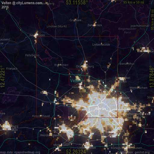
Analysis of Velten night lights 2016
Square area 10x10 km:
 0.79%
0.79%90-99
1.72%80-89
1.72%70-79
1.06%60-69
1.59%50-59
1.72%40-49
1.06%30-39
3.04%20-29
0.66%10-19
27.78%0-9
58.86%Square area 50x50 km:
7.03%90-99
4.56%80-89
1.29%70-79
1.24%60-69
1.6%50-59
1.79%40-49
1.97%30-39
2.1%20-29
3.04%10-19
5.93%0-9
69.47%Clear (daylight) street map image can be seen on geolist.org.
Map coordinates:
53° 6' 56.1" North, 12° 28' 20" East
52° 41' 29.4" North, 13° 10' 31.2" East
52° 15' 47.7" North, 13° 52' 42.5" East
Some cities around Velten sort by population:
• Oranienburg
8.4 km =5.2 mi,  32°
32°
• Hennigsdorf
6.5 km =4 mi,  162°
162°
• Hohen Neuendorf
7.1 km =4.4 mi,  103°
103°
• Heiligensee
9.8 km =6.1 mi,  151°
151°
• Frohnau
10.1 km =6.3 mi,  129°
129°
• Glienicke
12 km =7.5 mi,  122°
122°
• Birkenwerder
6.9 km =4.3 mi,  90°
90°
• Leegebruch
3.7 km =2.3 mi,  18°
18°
2817674 (p: 11,498)
Sources (retrieved 2019-11-25):
» Earth at Night: Flat Maps 2012, 2016