Leegebruch night lights from space
Night Light of Leegebruch (Brandenburg) from space (Germany) Src. Average luminocity for 10x10km area is 16.9975% and for 50x50km: 16.895%.
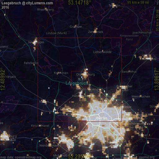
Analysis of Leegebruch night lights 2016
Square area 10x10 km:
 1.64%
1.64%90-99
1.52%80-89
1.39%70-79
2.4%60-69
3.16%50-59
4.04%40-49
2.02%30-39
3.03%20-29
0.63%10-19
20.58%0-9
59.6%Square area 50x50 km:
5.88%90-99
3.79%80-89
1.14%70-79
1.12%60-69
1.56%50-59
1.76%40-49
1.8%30-39
1.89%20-29
2.76%10-19
5.69%0-9
72.61%Clear (daylight) street map image can be seen on geolist.org.
Map coordinates:
53° 8' 49.8" North, 12° 29' 23.7" East
52° 43' 24.2" North, 13° 11' 34.9" East
52° 17' 43.7" North, 13° 53' 46.2" East
Some cities around Leegebruch sort by population:
• Oranienburg
4.9 km =3 mi,  42°
42°
• Hennigsdorf
9.7 km =6 mi,  175°
175°
• Hohen Neuendorf
7.7 km =4.8 mi,  132°
132°
• Heiligensee
12.6 km =7.8 mi,  163°
163°
• Frohnau
12 km =7.5 mi,  146°
146°
• Velten
3.7 km =2.3 mi,  198°
198°
• Kremmen
12.1 km =7.5 mi,  290°
290°
• Birkenwerder
6.8 km =4.2 mi,  122°
122°
2879713 (p: 6,541)
Sources (retrieved 2019-11-25):
» Earth at Night: Flat Maps 2012, 2016