Stahnsdorf night lights from space
Night Light of Stahnsdorf (Brandenburg) from space (Germany) Src. Average luminocity for 10x10km area is 46.7563% and for 50x50km: 32.2315%.
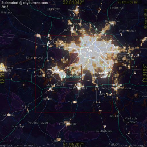
Analysis of Stahnsdorf night lights 2016
Square area 10x10 km:
 4.55%
4.55%90-99
8.96%80-89
10.61%70-79
6.19%60-69
5.56%50-59
5.81%40-49
3.79%30-39
6.31%20-29
28.41%10-19
17.8%0-9
2.02%Square area 50x50 km:
10.48%90-99
8.55%80-89
3.21%70-79
2.58%60-69
2.47%50-59
2.4%40-49
2.67%30-39
3.11%20-29
6.37%10-19
9%0-9
49.17%Clear (daylight) street map image can be seen on geolist.org.
Map coordinates:
52° 48' 37.5" North, 12° 30' 48.8" East
52° 22' 60" North, 13° 13' 0" East
51° 57' 7.5" North, 13° 55' 11.3" East
Some cities around Stahnsdorf sort by population:
• Lichterfelde
8.3 km =5.2 mi,  47°
47°
• Zehlendorf
6 km =3.7 mi,  22°
22°
• Ludwigsfelde
9.3 km =5.8 mi,  164°
164°
• Teltow
3.7 km =2.3 mi, 53°
• Kleinmachnow
2.8 km =1.7 mi,  11°
11°
• Nikolassee
5.8 km =3.6 mi,  349°
349°
• Wannsee
5.8 km =3.6 mi,  313°
313°
• Großbeeren
6.9 km =4.3 mi,  113°
113°
2829657 (p: 12,964)
Sources (retrieved 2019-11-25):
» Earth at Night: Flat Maps 2012, 2016