Kleinmachnow night lights from space
Night Light of Kleinmachnow (Brandenburg) from space (Germany) Src. Average luminocity for 10x10km area is 58.4293% and for 50x50km: 33.7817%.
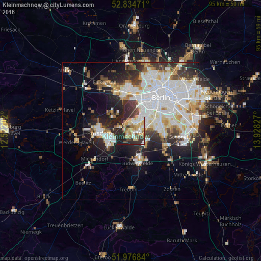
Analysis of Kleinmachnow night lights 2016
Square area 10x10 km:
 8.46%
8.46%90-99
14.14%80-89
13.01%70-79
8.71%60-69
7.45%50-59
6.31%40-49
3.54%30-39
7.32%20-29
21.59%10-19
9.47%0-9
0%Square area 50x50 km:
10.67%90-99
8.74%80-89
3.36%70-79
2.75%60-69
2.63%50-59
2.74%40-49
2.93%30-39
3.59%20-29
7.15%10-19
9.75%0-9
45.69%Clear (daylight) street map image can be seen on geolist.org.
Map coordinates:
52° 50' 5" North, 12° 31' 19.3" East
52° 24' 28.3" North, 13° 13' 30.5" East
51° 58' 36.6" North, 13° 55' 41.8" East
Some cities around Kleinmachnow sort by population:
• Lichterfelde
6.3 km =3.9 mi,  63°
63°
• Zehlendorf
3.3 km =2.1 mi,  30°
30°
• Teltow
2.4 km =1.5 mi,  102°
102°
• Nikolassee
3.4 km =2.1 mi,  330°
330°
• Dahlem
7 km =4.3 mi,  36°
36°
• Kladow
7.5 km =4.7 mi,  313°
313°
• Stahnsdorf
2.8 km =1.7 mi,  191°
191°
• Wannsee
4.9 km =3 mi,  284°
284°
2888523 (p: 17,892)
Sources (retrieved 2019-11-25):
» Earth at Night: Flat Maps 2012, 2016