Schwarzenfeld night lights from space
Night Light of Schwarzenfeld (Bavaria) from space (Germany) Src. Average luminocity for 10x10km area is 2.0922% and for 50x50km: 2.2612%.
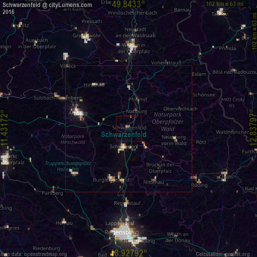
Analysis of Schwarzenfeld night lights 2016
Square area 10x10 km:
 0%
0%90-99
0%80-89
0.13%70-79
0.4%60-69
0%50-59
1.07%40-49
0.53%30-39
0%20-29
0%10-19
0.27%0-9
97.59%Square area 50x50 km:
0.22%90-99
0.3%80-89
0.28%70-79
0.25%60-69
0.29%50-59
0.36%40-49
0.45%30-39
0.32%20-29
0.4%10-19
0.52%0-9
96.6%Clear (daylight) street map image can be seen on geolist.org.
Map coordinates:
49° 50' 35.9" North, 11° 25' 54.2" East
49° 23' 15.9" North, 12° 8' 5.4" East
48° 55' 40.5" North, 12° 50' 16.7" East
Some cities around Schwarzenfeld sort by population:
• Amberg
20.6 km =12.8 mi,  287°
287°
• Maxhütte-Haidhof
21.1 km =13.1 mi,  188°
188°
• Kümmersbruck
18.2 km =11.3 mi,  281°
281°
• Neunburg vorm Wald
18.7 km =11.6 mi,  103°
103°
• Teublitz
18.7 km =11.6 mi, 190°
• Nabburg
8 km =5 mi,  24°
24°
• Wernberg-Köblitz
17 km =10.6 mi,  6°
6°
• Pfreimd
12 km =7.5 mi, 16°
2834945 (p: 6,398)
Sources (retrieved 2019-11-25):
» Earth at Night: Flat Maps 2012, 2016