Teublitz night lights from space
Night Light of Teublitz (Bavaria) from space (Germany) Src. Average luminocity for 10x10km area is 9.1484% and for 50x50km: 4.2523%.
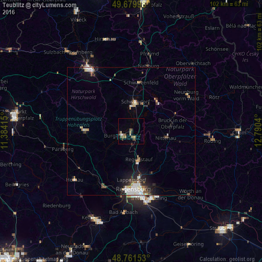
Analysis of Teublitz night lights 2016
Square area 10x10 km:
 0.27%
0.27%90-99
1.34%80-89
0.53%70-79
1.6%60-69
1.47%50-59
2.01%40-49
3.61%30-39
0.13%20-29
1.07%10-19
0.13%0-9
87.83%Square area 50x50 km:
0.79%90-99
0.84%80-89
0.38%70-79
0.41%60-69
0.41%50-59
0.45%40-49
0.74%30-39
0.32%20-29
0.99%10-19
2.02%0-9
92.64%Clear (daylight) street map image can be seen on geolist.org.
Map coordinates:
49° 40' 47.9" North, 11° 23' 2.9" East
49° 13' 22.4" North, 12° 5' 14.2" East
48° 45' 41.5" North, 12° 47' 25.4" East
Some cities around Teublitz sort by population:
• Schwandorf in Bayern
11.5 km =7.1 mi,  8°
8°
• Regenstauf
11.8 km =7.3 mi,  164°
164°
• Burglengenfeld
3.8 km =2.4 mi,  235°
235°
• Maxhütte-Haidhof
2.6 km =1.6 mi,  171°
171°
• Nittenau
13.5 km =8.4 mi,  103°
103°
• Wenzenbach
18.3 km =11.4 mi,  153°
153°
• Schwarzenfeld
18.7 km =11.6 mi, 10°
• Zeitlarn
16.2 km =10.1 mi, 173°
2823360 (p: 7,405)
Sources (retrieved 2019-11-25):
» Earth at Night: Flat Maps 2012, 2016