Pfreimd night lights from space
Night Light of Pfreimd (Bavaria) from space (Germany) Src. Average luminocity for 10x10km area is 2.0042% and for 50x50km: 2.5024%.
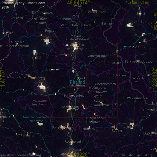
Analysis of Pfreimd night lights 2016
Square area 10x10 km:
 0%
0%90-99
0%80-89
0.28%70-79
0%60-69
0.84%50-59
0.14%40-49
0.98%30-39
0.56%20-29
0.56%10-19
1.12%0-9
95.52%Square area 50x50 km:
0.41%90-99
0.44%80-89
0.28%70-79
0.25%60-69
0.27%50-59
0.3%40-49
0.25%30-39
0.36%20-29
0.34%10-19
0.83%0-9
96.27%Clear (daylight) street map image can be seen on geolist.org.
Map coordinates:
49° 56' 44.7" North, 11° 28' 39.3" East
49° 29' 28.1" North, 12° 10' 50.5" East
49° 1' 56.2" North, 12° 53' 1.8" East
Some cities around Pfreimd sort by population:
• Weiden
20.7 km =12.9 mi,  355°
355°
• Schwandorf in Bayern
19.1 km =11.9 mi,  195°
195°
• Vohenstrauß
18.6 km =11.6 mi,  37°
37°
• Schwarzenfeld
12 km =7.5 mi, 196°
• Hirschau
17.9 km =11.1 mi,  289°
289°
• Nabburg
4.2 km =2.6 mi,  180°
180°
• Wernberg-Köblitz
5.5 km =3.4 mi,  345°
345°
• Oberviechtach
17.4 km =10.8 mi,  102°
102°
2853961 (p: 5,565)
Sources (retrieved 2019-11-25):
» Earth at Night: Flat Maps 2012, 2016